Search
Search Results
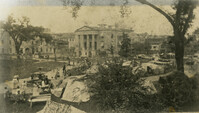
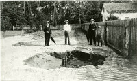
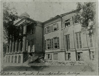
- Creator:
- [Leidloff, H. (Hermann)]
- Collection:
- Charleston Museum Earthquake Photographs
- Institution:
- The Charleston Museum Archives
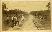
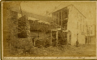
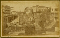
- Creator:
- Wisser, J. H., photographer.
- Collection:
- Charleston Earthquake 1886
- Institution:
- University of South Carolina. South Caroliniana Library
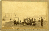
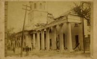
- Creator:
- Wilson, Wm. E.
- Collection:
- Primary Sources for K-12, Pilot Project
- Institution:
- University of South Carolina. South Caroliniana Library
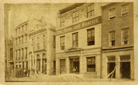
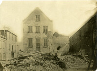
- Creator:
- Wilson, Wm. E.
- Collection:
- Primary Sources for K-12, Pilot Project
- Institution:
- University of South Carolina. South Caroliniana Library
- Creator:
- Savannah Photograph Gallery (Ga.) and Wilson, William E., photographer.
- Collection:
- Charleston Earthquake 1886
- Institution:
- University of South Carolina. South Caroliniana Library
- Creator:
- Wilson, William E., photographer.
- Collection:
- Charleston Earthquake 1886
- Institution:
- University of South Carolina. South Caroliniana Library
- Creator:
- Wilson, William E., photographer.
- Collection:
- Charleston Earthquake 1886
- Institution:
- University of South Carolina. South Caroliniana Library
- Creator:
- Wilson, William E., photographer.
- Collection:
- Charleston Earthquake 1886
- Institution:
- University of South Carolina. South Caroliniana Library
- Creator:
- Wilson, William E., photographer.
- Collection:
- Charleston Earthquake 1886
- Institution:
- University of South Carolina. South Caroliniana Library
- Creator:
- Wilson, William E., photographer.
- Collection:
- Charleston Earthquake 1886
- Institution:
- University of South Carolina. South Caroliniana Library
- Creator:
- Wilson, William E., photographer.
- Collection:
- Charleston Earthquake 1886
- Institution:
- University of South Carolina. South Caroliniana Library
- Creator:
- Wilson, William E., photographer.
- Collection:
- Charleston Earthquake 1886
- Institution:
- University of South Carolina. South Caroliniana Library
- Creator:
- Savannah Photograph Gallery (Ga.) and Wilson, William E., photographer.
- Collection:
- Charleston Earthquake 1886
- Institution:
- University of South Carolina. South Caroliniana Library
- Creator:
- Wilson, William E., photographer.
- Collection:
- Charleston Earthquake 1886
- Institution:
- University of South Carolina. South Caroliniana Library
- Creator:
- Wilson, William E., photographer.
- Collection:
- Charleston Earthquake 1886
- Institution:
- University of South Carolina. South Caroliniana Library
- Creator:
- Wilson, William E.
- Collection:
- Charleston Museum Earthquake Photographs
- Institution:
- The Charleston Museum Archives
- Creator:
- Wilson, William E.
- Collection:
- Charleston Museum Earthquake Photographs
- Institution:
- The Charleston Museum Archives
- Creator:
- Wilson, William E.
- Collection:
- Charleston Museum Earthquake Photographs
- Institution:
- The Charleston Museum Archives
- Creator:
- Wilson, William E.
- Collection:
- Charleston Museum Earthquake Photographs
- Institution:
- The Charleston Museum Archives
- Creator:
- Wilson, William E.
- Collection:
- Charleston Museum Earthquake Photographs
- Institution:
- The Charleston Museum Archives
- Creator:
- Wilkinson and Keith Families
- Collection:
- Wilkinson-Keith Family Papers
- Institution:
- College of Charleston Libraries
- Creator:
- Unknown
- Collection:
- Charleston Museum Earthquake Photographs
- Institution:
- The Charleston Museum Archives
- Creator:
- Unknown
- Collection:
- Charleston Museum Earthquake Photographs
- Institution:
- The Charleston Museum Archives
- Creator:
- Unknown
- Collection:
- Charleston Museum Earthquake Photographs
- Institution:
- The Charleston Museum Archives
- Creator:
- Unknown
- Collection:
- Charleston Museum Earthquake Photographs
- Institution:
- The Charleston Museum Archives
- Creator:
- Unknown
- Collection:
- Charleston Museum Earthquake Photographs
- Institution:
- The Charleston Museum Archives
- Creator:
- Unknown
- Collection:
- Charleston Museum Earthquake Photographs
- Institution:
- The Charleston Museum Archives
- Creator:
- Unknown
- Collection:
- Charleston Museum Earthquake Photographs
- Institution:
- The Charleston Museum Archives
- Creator:
- Unknown
- Collection:
- Charleston Museum Earthquake Photographs
- Institution:
- The Charleston Museum Archives
- Creator:
- Unknown
- Collection:
- Charleston Museum Earthquake Photographs
- Institution:
- The Charleston Museum Archives
- Creator:
- Unknown
- Collection:
- Charleston Museum Earthquake Photographs
- Institution:
- The Charleston Museum Archives
- Creator:
- Unknown
- Collection:
- Charleston Museum Earthquake Photographs
- Institution:
- The Charleston Museum Archives
- Creator:
- Unknown
- Collection:
- Charleston Museum Earthquake Photographs
- Institution:
- The Charleston Museum Archives
- Creator:
- Unknown
- Collection:
- Charleston Museum Earthquake Photographs
- Institution:
- The Charleston Museum Archives
- Creator:
- Unknown
- Collection:
- Charleston Museum Earthquake Photographs
- Institution:
- The Charleston Museum Archives
- Creator:
- Unknown
- Collection:
- Charleston Museum Earthquake Photographs
- Institution:
- The Charleston Museum Archives
- Creator:
- Unknown
- Collection:
- Charleston Museum Earthquake Photographs
- Institution:
- The Charleston Museum Archives
- Creator:
- Unknown
- Collection:
- Charleston Museum Earthquake Photographs
- Institution:
- The Charleston Museum Archives
- Creator:
- Unknown
- Collection:
- Charleston Museum Earthquake Photographs
- Institution:
- The Charleston Museum Archives
- Creator:
- Unknown
- Collection:
- Charleston Museum Earthquake Photographs
- Institution:
- The Charleston Museum Archives
- Creator:
- Unknown
- Collection:
- Charleston Museum Earthquake Photographs
- Institution:
- The Charleston Museum Archives
- Creator:
- Unknown
- Collection:
- Charleston Museum Earthquake Photographs
- Institution:
- The Charleston Museum Archives
- Creator:
- Unknown
- Collection:
- Charleston Museum Earthquake Photographs
- Institution:
- The Charleston Museum Archives
- Creator:
- Unknown
- Collection:
- Charleston Museum Earthquake Photographs
- Institution:
- The Charleston Museum Archives
- Creator:
- Unknown
- Collection:
- Charleston Museum Earthquake Photographs
- Institution:
- The Charleston Museum Archives
- Creator:
- Unknown
- Collection:
- Charleston Museum Earthquake Photographs
- Institution:
- The Charleston Museum Archives
- Creator:
- Unknown
- Collection:
- Charleston Museum Earthquake Photographs
- Institution:
- The Charleston Museum Archives
- Creator:
- Unknown
- Collection:
- Charleston Museum Earthquake Photographs
- Institution:
- The Charleston Museum Archives
- Creator:
- Unknown
- Collection:
- Charleston Museum Earthquake Photographs
- Institution:
- The Charleston Museum Archives
- Creator:
- Unknown
- Collection:
- Charleston Museum Earthquake Photographs
- Institution:
- The Charleston Museum Archives
- Creator:
- Unknown
- Collection:
- Charleston Museum Earthquake Photographs
- Institution:
- The Charleston Museum Archives
- Creator:
- Unknown
- Collection:
- Charleston Museum Earthquake Photographs
- Institution:
- The Charleston Museum Archives
- Creator:
- Unknown
- Collection:
- Charleston Museum Earthquake Photographs
- Institution:
- The Charleston Museum Archives
- Creator:
- Unknown
- Collection:
- Charleston Museum Earthquake Photographs
- Institution:
- The Charleston Museum Archives
- Creator:
- Taylor, John C. (Photographer)
- Collection:
- Chibbaro Stereograph Collection: 186u-1997
- Institution:
- University of South Carolina. South Caroliniana Library
- Creator:
- Stryker, William S. (William Scudder), 1838-1900
- Collection:
- Civil War Pamphlets
- Institution:
- Greenville County Library System
- Creator:
- Simons, S. Lewis
- Collection:
- South Caroliniana Library Map Collection
- Institution:
- University of South Carolina. South Caroliniana Library
- Creator:
- Palmer, J.A. (James A.)
- Collection:
- Charleston Museum Earthquake Photographs
- Institution:
- The Charleston Museum Archives
- Creator:
- Palmer, J.A. (James A.)
- Collection:
- Charleston Museum Earthquake Photographs
- Institution:
- The Charleston Museum Archives
- Creator:
- Palmer, J.A. (James A.)
- Collection:
- Charleston Museum Earthquake Photographs
- Institution:
- The Charleston Museum Archives
- Creator:
- Leidloff, H. (Hermann)
- Collection:
- Charleston Museum Earthquake Photographs
- Institution:
- The Charleston Museum Archives
- Creator:
- Leidloff, H. (Hermann)
- Collection:
- Charleston Museum Earthquake Photographs
- Institution:
- The Charleston Museum Archives
- Creator:
- Kensington Art Studio, photographer.
- Collection:
- Charleston Earthquake 1886
- Institution:
- University of South Carolina. South Caroliniana Library
- Creator:
- Hall, Joseph, photographer. and Kensington Art Studio (Brooklyn, N.Y.)
- Collection:
- Charleston Earthquake 1886
- Institution:
- University of South Carolina. South Caroliniana Library
- Creator:
- Kensington Art Studio (Brooklyn, N.Y.)
- Collection:
- Charleston Earthquake 1886
- Institution:
- University of South Carolina. South Caroliniana Library
- Creator:
- Howland, E.P.
- Collection:
- Charleston Museum Earthquake Photographs
- Institution:
- The Charleston Museum Archives
- Creator:
- Howland, E.P.
- Collection:
- Charleston Museum Earthquake Photographs
- Institution:
- The Charleston Museum Archives
- Creator:
- Howland, E.P.
- Collection:
- Charleston Museum Earthquake Photographs
- Institution:
- The Charleston Museum Archives
- Creator:
- Howland, E.P.
- Collection:
- Charleston Museum Earthquake Photographs
- Institution:
- The Charleston Museum Archives
- Creator:
- Howland, E.P.
- Collection:
- Charleston Museum Earthquake Photographs
- Institution:
- The Charleston Museum Archives
- Creator:
- Hillers, John K., 1843-1925.
- Collection:
- Charleston Earthquake 1886
- Institution:
- University of South Carolina. South Caroliniana Library
- Creator:
- Hillers, John K., 1843-1925.
- Collection:
- Charleston Earthquake 1886
- Institution:
- University of South Carolina. South Caroliniana Library
- Creator:
- Hillers, John K., 1843-1925.
- Collection:
- Charleston Earthquake 1886
- Institution:
- University of South Carolina. South Caroliniana Library
- Creator:
- Hillers, John K., 1843-1925.
- Collection:
- Charleston Earthquake 1886
- Institution:
- University of South Carolina. South Caroliniana Library
- Creator:
- Hillers, John K., 1843-1925.
- Collection:
- Charleston Earthquake 1886
- Institution:
- University of South Carolina. South Caroliniana Library
- Creator:
- Hillers, John K., 1843-1925.
- Collection:
- Charleston Earthquake 1886
- Institution:
- University of South Carolina. South Caroliniana Library
- Creator:
- Hillers, John K., 1843-1925.
- Collection:
- Charleston Earthquake 1886
- Institution:
- University of South Carolina. South Caroliniana Library
- Creator:
- Hillers, John K., 1843-1925.
- Collection:
- Charleston Earthquake 1886
- Institution:
- University of South Carolina. South Caroliniana Library
- Creator:
- Hillers, John K., 1843-1925.
- Collection:
- Charleston Earthquake 1886
- Institution:
- University of South Carolina. South Caroliniana Library
- Creator:
- Hillers, John K., 1843-1925.
- Collection:
- Charleston Earthquake 1886
- Institution:
- University of South Carolina. South Caroliniana Library
- Creator:
- Hillers, John K., 1843-1925.
- Collection:
- Charleston Earthquake 1886
- Institution:
- University of South Carolina. South Caroliniana Library
- Creator:
- Hillers, John K., 1843-1925.
- Collection:
- Charleston Earthquake 1886
- Institution:
- University of South Carolina. South Caroliniana Library
- Creator:
- Hillers, John K., 1843-1925.
- Collection:
- Charleston Earthquake 1886
- Institution:
- University of South Carolina. South Caroliniana Library
- Creator:
- Hillers, John K., 1843-1925.
- Collection:
- Charleston Earthquake 1886
- Institution:
- University of South Carolina. South Caroliniana Library
- Creator:
- Hillers, John K., 1843-1925.
- Collection:
- Charleston Earthquake 1886
- Institution:
- University of South Carolina. South Caroliniana Library
- Creator:
- Hillers, John K., 1843-1925.
- Collection:
- Charleston Earthquake 1886
- Institution:
- University of South Carolina. South Caroliniana Library
- Creator:
- Hillers, John K., 1843-1925.
- Collection:
- Charleston Earthquake 1886
- Institution:
- University of South Carolina. South Caroliniana Library
- Creator:
- Hillers, John K., 1843-1925.
- Collection:
- Charleston Earthquake 1886
- Institution:
- University of South Carolina. South Caroliniana Library
- Creator:
- Hillers, John K., 1843-1925.
- Collection:
- Charleston Earthquake 1886
- Institution:
- University of South Carolina. South Caroliniana Library
- Creator:
- Hillers, John K., 1843-1925.
- Collection:
- Charleston Earthquake 1886
- Institution:
- University of South Carolina. South Caroliniana Library
- Creator:
- Hillers, John K., 1843-1925.
- Collection:
- Charleston Earthquake 1886
- Institution:
- University of South Carolina. South Caroliniana Library
- Creator:
- Hillers, John K., 1843-1925.
- Collection:
- Charleston Earthquake 1886
- Institution:
- University of South Carolina. South Caroliniana Library
- Creator:
- Hillers, John K., 1843-1925.
- Collection:
- Charleston Earthquake 1886
- Institution:
- University of South Carolina. South Caroliniana Library
- Creator:
- Hillers, John K., 1843-1925.
- Collection:
- Charleston Earthquake 1886
- Institution:
- University of South Carolina. South Caroliniana Library
- Creator:
- Hillers, John K., 1843-1925, photographer.
- Collection:
- Charleston Earthquake 1886
- Institution:
- University of South Carolina. South Caroliniana Library
- Creator:
- Heliotype Printing Company of Boston
- Collection:
- Charleston Earthquake 1886
- Institution:
- University of South Carolina. South Caroliniana Library
- Creator:
- Heliotype Printing Company of Boston
- Collection:
- Charleston Earthquake 1886
- Institution:
- University of South Carolina. South Caroliniana Library
- Creator:
- Heliotype Printing Company of Boston
- Collection:
- Charleston Earthquake 1886
- Institution:
- University of South Carolina. South Caroliniana Library
- Creator:
- Heliotype Printing Company of Boston
- Collection:
- Charleston Earthquake 1886
- Institution:
- University of South Carolina. South Caroliniana Library
- Creator:
- Heliotype Printing Company of Boston
- Collection:
- Charleston Earthquake 1886
- Institution:
- University of South Carolina. South Caroliniana Library