Search
Search Results
- Creator:
- Schuck-Kolben, R. E.
- Collection:
- Hurricane Hugo Elevation Maps
- Institution:
- University of South Carolina. Government Information and Maps Department
- Creator:
- South Carolina Department of Transportation
- Collection:
- South Carolina Department of Transportation County Road Maps
- Institution:
- University of South Carolina. Government Information and Maps Department
- Creator:
- South Carolina Department of Transportation
- Collection:
- South Carolina Department of Transportation County Road Maps
- Institution:
- University of South Carolina. Government Information and Maps Department
- Creator:
- South Carolina Department of Transportation
- Collection:
- South Carolina Department of Transportation County Road Maps
- Institution:
- University of South Carolina. Government Information and Maps Department
- Creator:
- South Carolina Department of Transportation
- Collection:
- South Carolina Department of Transportation County Road Maps
- Institution:
- University of South Carolina. Government Information and Maps Department
- Collection:
- South Caroliniana Library Map Collection
- Institution:
- University of South Carolina. South Caroliniana Library
- Creator:
- Berkeley-Charleston-Dorchester Regional Planning Council
- Collection:
- South Caroliniana Library Map Collection
- Institution:
- University of South Carolina. South Caroliniana Library
- Collection:
- South Caroliniana Library Map Collection
- Institution:
- University of South Carolina. South Caroliniana Library
- Creator:
- South Carolina Department of Transportation
- Collection:
- South Carolina Department of Transportation County Road Maps
- Institution:
- University of South Carolina. Government Information and Maps Department
- Creator:
- South Carolina Department of Transportation
- Collection:
- South Carolina Department of Transportation County Road Maps
- Institution:
- University of South Carolina. Government Information and Maps Department
- Creator:
- South Carolina Department of Transportation
- Collection:
- South Carolina Department of Transportation County Road Maps
- Institution:
- University of South Carolina. Government Information and Maps Department
- Creator:
- South Carolina Department of Transportation
- Collection:
- South Carolina Department of Transportation County Road Maps
- Institution:
- University of South Carolina. Government Information and Maps Department
- Creator:
- South Carolina Department of Transportation
- Collection:
- South Carolina Department of Transportation County Road Maps
- Institution:
- University of South Carolina. Government Information and Maps Department
- Creator:
- South Carolina Department of Transportation
- Collection:
- South Carolina Department of Transportation County Road Maps
- Institution:
- University of South Carolina. Government Information and Maps Department
- Creator:
- South Carolina Department of Transportation
- Collection:
- South Carolina Department of Transportation County Road Maps
- Institution:
- University of South Carolina. Government Information and Maps Department
- Creator:
- South Carolina Department of Transportation
- Collection:
- South Carolina Department of Transportation County Road Maps
- Institution:
- University of South Carolina. Government Information and Maps Department
- Collection:
- South Caroliniana Library Map Collection
- Institution:
- University of South Carolina. South Caroliniana Library
- Collection:
- South Caroliniana Library Map Collection
- Institution:
- University of South Carolina. South Caroliniana Library
- Collection:
- South Caroliniana Library Map Collection
- Institution:
- University of South Carolina. South Caroliniana Library
- Creator:
- South Carolina Department of Transportation
- Collection:
- South Carolina Department of Transportation County Road Maps
- Institution:
- University of South Carolina. Government Information and Maps Department
- Creator:
- South Carolina Department of Transportation
- Collection:
- South Carolina Department of Transportation County Road Maps
- Institution:
- University of South Carolina. Government Information and Maps Department
- Creator:
- South Carolina Department of Transportation
- Collection:
- South Carolina Department of Transportation County Road Maps
- Institution:
- University of South Carolina. Government Information and Maps Department
- Creator:
- Sanborn Fire Insurance Map Company
- Collection:
- Sanborn Fire Insurance Maps of South Carolina
- Institution:
- University of South Carolina. South Caroliniana Library
- Creator:
- United States. Army. Corps of Engineers
- Collection:
- Topographical Maps of South Carolina, 1888 -1975
- Institution:
- University of South Carolina. Government Information and Maps Department
- Creator:
- Sanborn Fire Insurance Map Company
- Collection:
- Sanborn Fire Insurance Maps of South Carolina
- Institution:
- University of South Carolina. South Caroliniana Library
- Creator:
- Ruff, D.G.
- Collection:
- South Caroliniana Library Map Collection
- Institution:
- University of South Carolina. South Caroliniana Library
- Creator:
- United States. Army. Corps of Engineers
- Collection:
- Topographical Maps of South Carolina, 1888 -1975
- Institution:
- University of South Carolina. Government Information and Maps Department
- Creator:
- United States. Army. Corps of Engineers
- Collection:
- Topographical Maps of South Carolina, 1888 -1975
- Institution:
- University of South Carolina. Government Information and Maps Department
- Creator:
- South Carolina Department of Transportation
- Collection:
- South Carolina Department of Transportation County Road Maps
- Institution:
- University of South Carolina. Government Information and Maps Department
- Creator:
- Sanborn Fire Insurance Map Company
- Collection:
- Sanborn Fire Insurance Maps of South Carolina
- Institution:
- University of South Carolina. South Caroliniana Library
- Creator:
- Sanborn Fire Insurance Map Company
- Collection:
- Sanborn Fire Insurance Maps of South Carolina
- Institution:
- University of South Carolina. South Caroliniana Library
- Creator:
- Sanborn Fire Insurance Map Company
- Collection:
- Sanborn Fire Insurance Maps of South Carolina
- Institution:
- University of South Carolina. South Caroliniana Library
- Creator:
- Sanborn Fire Insurance Map Company
- Collection:
- Sanborn Fire Insurance Maps of South Carolina
- Institution:
- University of South Carolina. South Caroliniana Library
- Collection:
- South Caroliniana Library Map Collection
- Institution:
- University of South Carolina. South Caroliniana Library
- Creator:
- Marshall, R. B. (Robert Bradford), 1867-1949 (Geographer) and Herron, W. H. (William Harrison), 1865- (Geographer)
- Collection:
- South Caroliniana Library Map Collection
- Institution:
- University of South Carolina. South Caroliniana Library
- Creator:
- United States. Department of Agriculture
- Collection:
- USDA Historical Soil Survey Maps of South Carolina Digital Collection
- Institution:
- University of South Carolina. Government Information and Maps Department
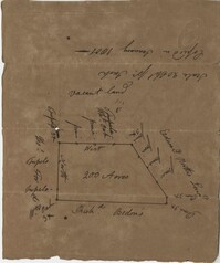
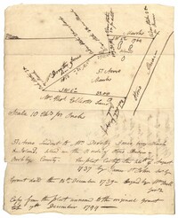
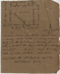
- Collection:
- John McCrady Plats and Deeds Collection
- Institution:
- South Carolina Historical Society
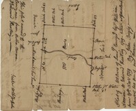
- Collection:
- John McCrady Plats and Deeds Collection
- Institution:
- South Carolina Historical Society
- Creator:
- Simons, S. Lewis
- Collection:
- South Caroliniana Library Map Collection
- Institution:
- University of South Carolina. South Caroliniana Library
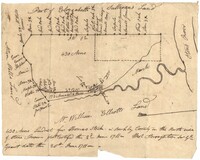
- Collection:
- John McCrady Plats and Deeds Collection
- Institution:
- South Carolina Historical Society
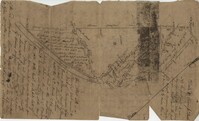
- Collection:
- John McCrady Plats and Deeds Collection
- Institution:
- South Carolina Historical Society
- Creator:
- Akin, James, approximately 1773-1846 (Cartographer)
- Collection:
- South Caroliniana Library Map Collection
- Institution:
- University of South Carolina. South Caroliniana Library
- Creator:
- Senf, John (Johann) Christian and Gaillard, J. P.
- Collection:
- South Caroliniana Library Map Collection
- Institution:
- University of South Carolina. South Caroliniana Library
- Collection:
- John McCrady Plats and Deeds Collection
- Institution:
- South Carolina Historical Society
- Collection:
- John McCrady Plats and Deeds Collection
- Institution:
- South Carolina Historical Society
- Collection:
- John McCrady Plats and Deeds Collection
- Institution:
- South Carolina Historical Society
- Collection:
- John McCrady Plats and Deeds Collection
- Institution:
- South Carolina Historical Society
- Collection:
- John McCrady Plats and Deeds Collection
- Institution:
- South Carolina Historical Society
- Collection:
- John McCrady Plats and Deeds Collection
- Institution:
- South Carolina Historical Society
- Collection:
- John McCrady Plats and Deeds Collection
- Institution:
- South Carolina Historical Society
- Collection:
- John McCrady Plats and Deeds Collection
- Institution:
- South Carolina Historical Society
- Collection:
- John McCrady Plats and Deeds Collection
- Institution:
- South Carolina Historical Society
- Creator:
- Senf, John Christian (Engineer)
- Collection:
- South Caroliniana Library Map Collection
- Institution:
- University of South Carolina. South Caroliniana Library
- Creator:
- Atlantic Coast Lumber Company
- Collection:
- South Caroliniana Library Map Collection
- Institution:
- University of South Carolina. South Caroliniana Library
- Institution:
- University of South Carolina. South Caroliniana Library
- Collection:
- John McCrady Plats and Deeds Collection
- Institution:
- South Carolina Historical Society
- Collection:
- John McCrady Plats and Deeds Collection
- Institution:
- South Carolina Historical Society
- Collection:
- John McCrady Plats and Deeds Collection
- Institution:
- South Carolina Historical Society