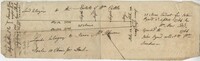
Confederate States of America. Army, Confederate States of America. Army. Corps of Engineers, Walker, William A., Johnson, John, Echols, William H., -1909, and Key, John Ross, 1832-1920
Collection:
South Caroliniana Library Map Collection
Institution:
University of South Carolina. South Caroliniana Library
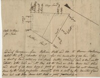
Gravelot, Hubert Francois, 1699-1773(delin.), Roberts, Bishop, Toms, W. H. (William Henry), approximately 1700-approximately 1750(engraver), and Kohn-Hennig Collection.
Collection:
South Caroliniana Library Map Collection
Institution:
University of South Carolina. South Caroliniana Library
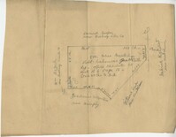
Bache, A.D. (Alexander Dallas),1806-1867, Boutelle, C.O. (Charles Otis), Wainwright, S.A., Craven, Tunis A. M., 1813-1864, Maffitt, John Newland, 1819-1886, Farquhar, G. (Cartographer), Williams, L.D. (Cartographer), Smith, W. (Engraver), and Yeager, E. (Edward) (Engraver)
Collection:
South Caroliniana Library Map Collection
Institution:
University of South Carolina. South Caroliniana Library