Skip to search
Skip to main content
Skip to first result
Search
Search Results
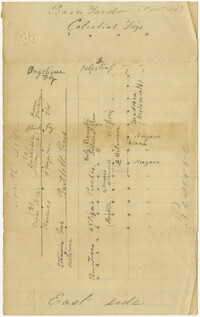
Collection:
Fairfield Plantation Papers
Institution:
College of Charleston Libraries
Collection:
Fairfield Plantation Papers
Institution:
College of Charleston Libraries
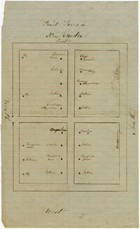
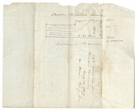
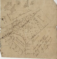
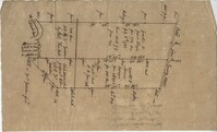
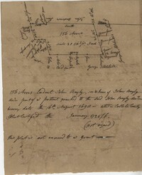
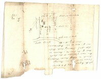
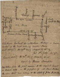
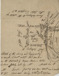
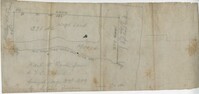
Collection:
John McCrady Plats and Deeds Collection
Institution:
South Carolina Historical Society
Collection:
John McCrady Plats and Deeds Collection
Institution:
South Carolina Historical Society
Collection:
John McCrady Plats and Deeds Collection
Institution:
South Carolina Historical Society
Collection:
John McCrady Plats and Deeds Collection
Institution:
South Carolina Historical Society
Collection:
John McCrady Plats and Deeds Collection
Institution:
South Carolina Historical Society
Collection:
John McCrady Plats and Deeds Collection
Institution:
South Carolina Historical Society
Collection:
John McCrady Plats and Deeds Collection
Institution:
South Carolina Historical Society
Collection:
John McCrady Plats and Deeds Collection
Institution:
South Carolina Historical Society
Creator:
United States. Army. Corps of Engineers
Collection:
Topographical Maps of South Carolina, 1888 -1975
Institution:
University of South Carolina. Government Information and Maps Department
Creator:
United States. Army. Corps of Engineers
Collection:
Topographical Maps of South Carolina, 1888 -1975
Institution:
University of South Carolina. Government Information and Maps Department
Creator:
United States. Army. Corps of Engineers
Collection:
Topographical Maps of South Carolina, 1888 -1975
Institution:
University of South Carolina. Government Information and Maps Department
Creator:
United States. Army. Corps of Engineers
Collection:
Topographical Maps of South Carolina, 1888 -1975
Institution:
University of South Carolina. Government Information and Maps Department
Creator:
United States. Army. Corps of Engineers
Collection:
Topographical Maps of South Carolina, 1888 -1975
Institution:
University of South Carolina. Government Information and Maps Department
Creator:
United States. Army. Corps of Engineers
Collection:
Topographical Maps of South Carolina, 1888 -1975
Institution:
University of South Carolina. Government Information and Maps Department
Creator:
United States. Army. Corps of Engineers
Collection:
Topographical Maps of South Carolina, 1888 -1975
Institution:
University of South Carolina. Government Information and Maps Department
Creator:
United States. Army. Corps of Engineers
Collection:
Topographical Maps of South Carolina, 1888 -1975
Institution:
University of South Carolina. Government Information and Maps Department
Creator:
United States. Army. Corps of Engineers
Collection:
Topographical Maps of South Carolina, 1888 -1975
Institution:
University of South Carolina. Government Information and Maps Department
Collection:
South Caroliniana Library Map Collection
Institution:
University of South Carolina. South Caroliniana Library
Institution:
University of South Carolina. South Caroliniana Library
Creator:
Mrs. F.D.Slaght, Jr.
Collection:
South Caroliniana Library Map Collection
Institution:
University of South Carolina. South Caroliniana Library
Collection:
South Caroliniana Library Map Collection
Institution:
University of South Carolina. South Caroliniana Library
Creator:
Martin Flegel
Collection:
South Caroliniana Library Map Collection
Institution:
University of South Carolina. South Caroliniana Library
Creator:
Martin Flegel
Collection:
South Caroliniana Library Map Collection
Institution:
University of South Carolina. South Caroliniana Library
Collection:
South Caroliniana Library Map Collection
Institution:
University of South Carolina. South Caroliniana Library
Creator:
Mouzon, Henry and Cook, James, 1728-1779
Collection:
South Caroliniana Library Map Collection
Institution:
University of South Carolina. South Caroliniana Library
Creator:
Bache, A.D. (Alexander Dallas),1806-1867, Boutelle, C.O. (Charles Otis), Wainwright, S.A., Craven, Tunis A. M., 1813-1864, Maffitt, John Newland, 1819-1886, Farquhar, G. (Cartographer), Williams, L.D. (Cartographer), Smith, W. (Engraver), and Yeager, E. (Edward) (Engraver)
Collection:
South Caroliniana Library Map Collection
Institution:
University of South Carolina. South Caroliniana Library
Creator:
Atlantic Coast Lumber Company
Collection:
South Caroliniana Library Map Collection
Institution:
University of South Carolina. South Caroliniana Library
Creator:
South Carolina Department of Transportation
Collection:
South Carolina Department of Transportation County Road Maps
Institution:
University of South Carolina. Government Information and Maps Department
Creator:
South Carolina Department of Transportation
Collection:
South Carolina Department of Transportation County Road Maps
Institution:
University of South Carolina. Government Information and Maps Department
Creator:
South Carolina Department of Transportation
Collection:
South Carolina Department of Transportation County Road Maps
Institution:
University of South Carolina. Government Information and Maps Department
Creator:
South Carolina Department of Transportation
Collection:
South Carolina Department of Transportation County Road Maps
Institution:
University of South Carolina. Government Information and Maps Department
Creator:
South Carolina Department of Transportation
Collection:
South Carolina Department of Transportation County Road Maps
Institution:
University of South Carolina. Government Information and Maps Department
Creator:
South Carolina Department of Transportation
Collection:
South Carolina Department of Transportation County Road Maps
Institution:
University of South Carolina. Government Information and Maps Department
Creator:
South Carolina Department of Transportation
Collection:
South Carolina Department of Transportation County Road Maps
Institution:
University of South Carolina. Government Information and Maps Department
Creator:
South Carolina Department of Transportation
Collection:
South Carolina Department of Transportation County Road Maps
Institution:
University of South Carolina. Government Information and Maps Department
Creator:
South Carolina Department of Transportation
Collection:
South Carolina Department of Transportation County Road Maps
Institution:
University of South Carolina. Government Information and Maps Department
Creator:
South Carolina Department of Transportation
Collection:
South Carolina Department of Transportation County Road Maps
Institution:
University of South Carolina. Government Information and Maps Department
Creator:
South Carolina Department of Transportation
Collection:
South Carolina Department of Transportation County Road Maps
Institution:
University of South Carolina. Government Information and Maps Department
Creator:
South Carolina Department of Transportation
Collection:
South Carolina Department of Transportation County Road Maps
Institution:
University of South Carolina. Government Information and Maps Department
Creator:
South Carolina Department of Transportation
Collection:
South Carolina Department of Transportation County Road Maps
Institution:
University of South Carolina. Government Information and Maps Department
Creator:
South Carolina Department of Transportation
Collection:
South Carolina Department of Transportation County Road Maps
Institution:
University of South Carolina. Government Information and Maps Department
Creator:
South Carolina Department of Transportation
Collection:
South Carolina Department of Transportation County Road Maps
Institution:
University of South Carolina. Government Information and Maps Department
Creator:
Colton, J. H. (Joseph Hutchins), 1800-1893
Collection:
South Carolina and the Civil War
Institution:
University of South Carolina. South Caroliniana Library
Creator:
Evans & Cogswell
Collection:
South Carolina and the Civil War
Institution:
University of South Carolina. South Caroliniana Library
Creator:
Bien, Julius, 1826-1909.
Collection:
South Carolina and the Civil War
Institution:
University of South Carolina. South Caroliniana Library
Creator:
Sanborn Fire Insurance Map Company
Collection:
Sanborn Fire Insurance Maps of South Carolina
Institution:
University of South Carolina. South Caroliniana Library
Creator:
Sanborn Fire Insurance Map Company
Collection:
Sanborn Fire Insurance Maps of South Carolina
Institution:
University of South Carolina. South Caroliniana Library
Creator:
Sanborn Fire Insurance Map Company
Collection:
Sanborn Fire Insurance Maps of South Carolina
Institution:
University of South Carolina. South Caroliniana Library